Related Media: mountains
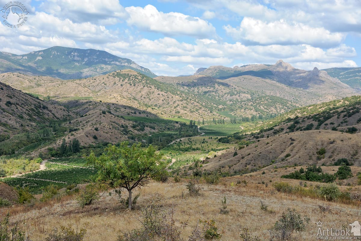
View from the motorway in the southeast of the Crimean peninsula on the mountain landscape with vegetation, trees and vineyards, blue sky with clouds on a beautiful summer sunny day. It is the place between the villages of Morskoye and Privetnoye, not far from the Black Sea coast, between the two large cities of Sudak and Alushta.
Photo #027 taken on August 19, 2019
| Album | Crimean Landscapes |
| Categories | Landscapes, Nature |
| Taken | August 19, 2019 |
| Uploaded | March 20, 2021 |
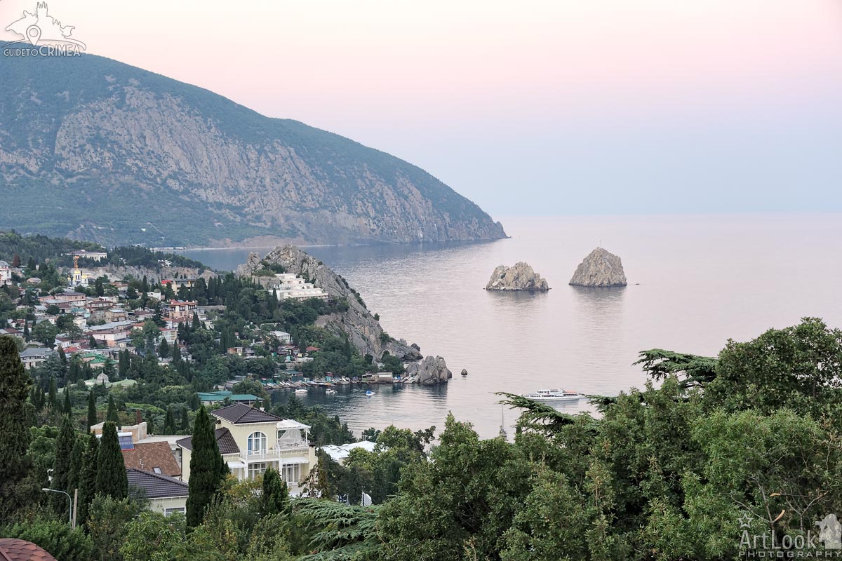
Overview Gurzuf bay from Snegiri Guest House at sunset in summer. In the picture: Gurzuf settlement, Gurzuf bay and Adalary twin-rocks, and Mount Au-Dag (Bear Mountain) in the background. Gurzuf is the popular resort-town (urban-type settlement) located 11 km East from Yalta city.
Photo #320 taken on August 12, 2019 during adventure trip “Discovering Crimea within One Week” with my Dear clients from Hong Kong, Esther and Ricky.
| Album | Gurzuf |
| Categories | Landscapes, Nature |
| Taken | August 12, 2019 |
| Uploaded | March 19, 2021 |
Crimean landscape on the road between Koktebel and Shebetovka in the background of the mountains of Karadag Nature Reserve.
Photo #304 taken on September 14, 2013
| Album | Crimean Landscapes |
| Category | Landscapes |
| Taken | August 27, 2015 |
| Uploaded | November 11, 2019 |
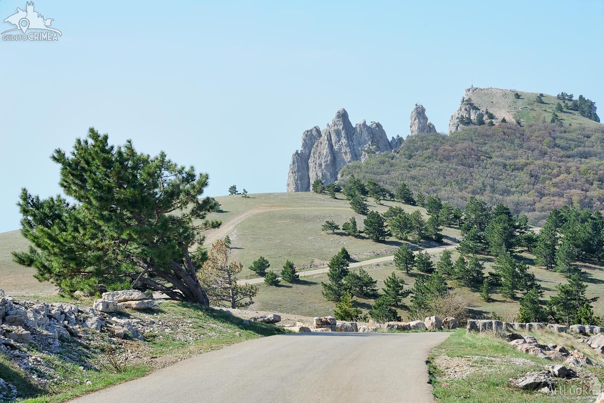
Quick stop on a serpentine road in mountains to overview a valley near the famous Crimean Mountain Demerdzhi in Alushta covered with clouds and fog.
Photo #406 taken on May 06, 2017
| Album | Crimean Landscapes |
| Category | Landscapes |
| Taken | May 6, 2017 |
| Uploaded | November 11, 2019 |
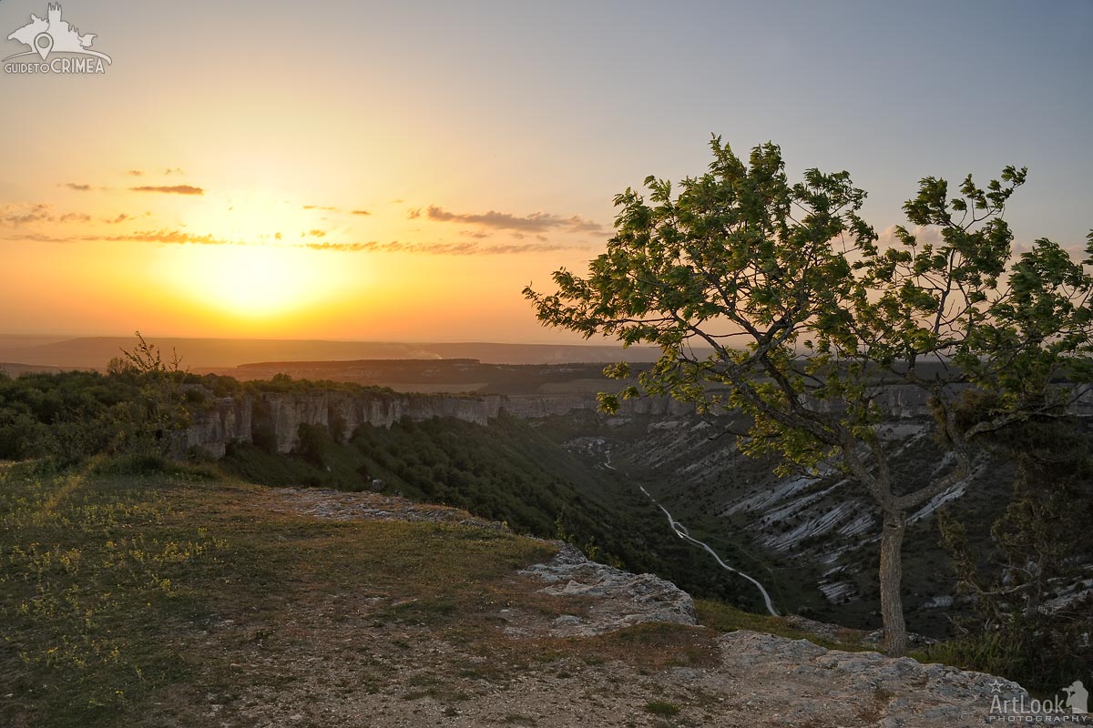
Beautiful Crimean landscape at sunset with a lonely standing tree on the mountain plateau of Burunchak near the Maryam-Dere (St. Maria) gully (not far from the Holy Dormition Cave Monastery) in Bakhchisaray.
Photo #925 taken on May 04, 2017
| Album | Crimean Landscapes |
| Category | Landscapes |
| Taken | May 4, 2017 |
| Uploaded | November 11, 2019 |

Overview mountains and large vineyards at the southern shore of Crimean Peninsula near a village Uskut, Alushta district.
Photo #087 taken on August 09, 2019
| Album | Crimean Landscapes |
| Category | Landscapes |
| Taken | August 9, 2019 |
| Uploaded | November 11, 2019 |
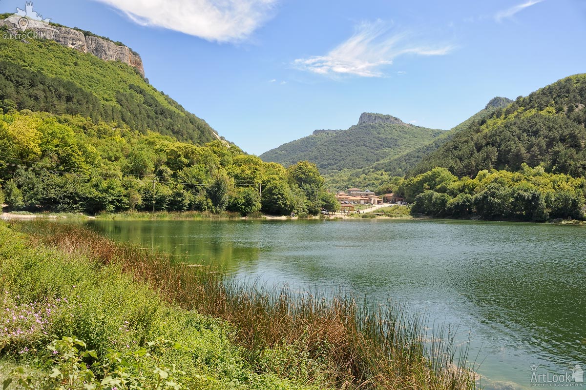
Amazing, picturesque mountain landscape of the central part of Crimea at Lake Devichye (Eng: Maiden; locals call it Lake Mangup) with a view of the village of Khoja-Sale located at the foot of Mangup Mountain. The ruins of Mangup-Kale, an ancient cave city, have been preserved not far from this place. The Devichye (Maiden) at the foot of Mount Mangup, surrounded by sheer cliffs, is very young. It was created by man 40 years ago. Mangup lake was formed thanks to the purposeful construction work that was carried out here in 1982-1984. The excavated pit was gradually filled with water coming from the springs that opened during excavation. So there was a reservoir, which began to exist independently and turned into a real natural object.
Photo #123 taken on August 17, 2019
| Album | Crimean Landscapes |
| Category | Landscapes |
| Taken | August 17, 2019 |
| Uploaded | November 11, 2019 |
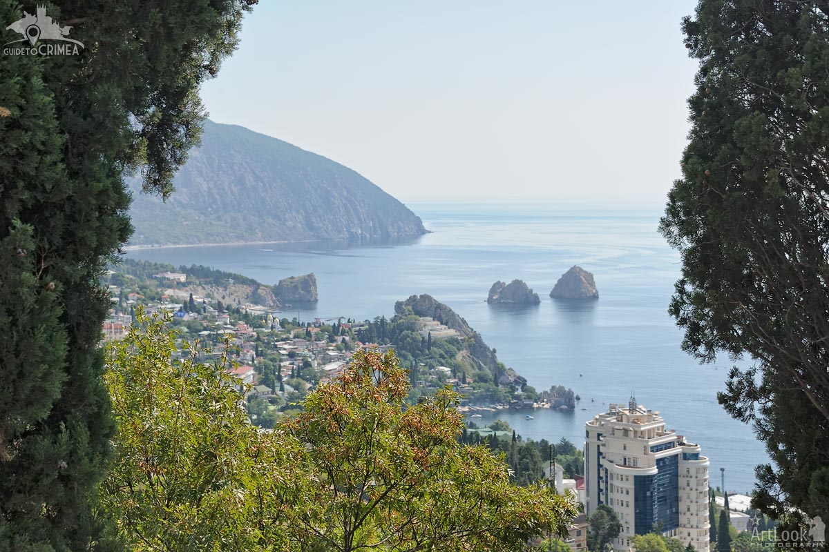
View of Gurzuf bay framed by trees from an observation deck at the top of a hill on Gurzufskoye highway. The edge of Mount Au-Dag (Bear Mountain), twin-rocks Adalary, Skalny (Rocky) Hotel on the Genoese Rock with a peer of Chekhov’s Dacha at the bottom, old and modern buildings of Gurzuf you can see on this picture. Gurzuf is the popular resort-town (urban-type settlement) located in 11 km East from Yalta city.
Photo #021 taken on August 19, 2019
| Album | Crimean Landscapes |
| Category | Landscapes |
| Taken | August 19, 2019 |
| Uploaded | November 11, 2019 |
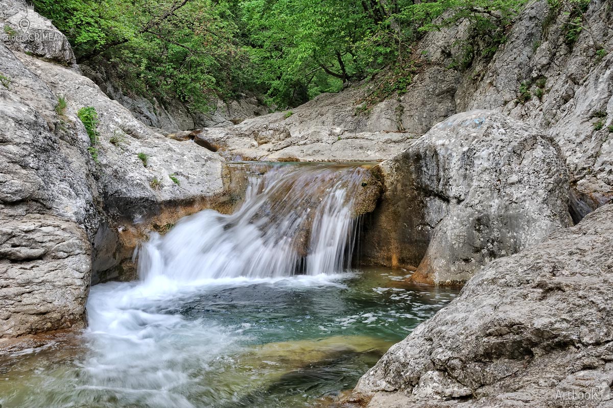
A small waterfall in the Grand Canyon filling the deep natural bath Kara-gol formed by Auzun-Uzen river (stream). The river flows at the bottom of the Canyon with multitude of blocks and boulders, forms over hundred of 2-3 meter deep erosive cauldrons and gullies that look like porcelain sinks. These are so called baths. Kara-gol is the largest natural font, located on the road from Yalta to the peak of Ai-Petri. Even in extreme heat, the water temperature in the font nicknamed “Bath of Youth” does not exceed 11-12 degrees. Kara-gol has an average diameter of about 5 meters, or rather, the bath is almost rectangular, 3 by 6 meters and a depth of 6 meters. From a ledge, 3 meters high, jets of a very pretty waterfall flow into it. The parameters of the “bath” completely allow those who wish to dive from a towering stone ledge without fear of injury. But the waterfall is just the appearance of filling the font. In fact, water enters the small mountain lake from a spring that does not dry during the hottest time, and is 150 meters higher from the ground.
Photo #693 taken on May 04, 2017
| Album | Ai-Petri Mountain |
| Category | Landscapes |
| Taken | May 4, 2017 |
| Uploaded | November 9, 2019 |
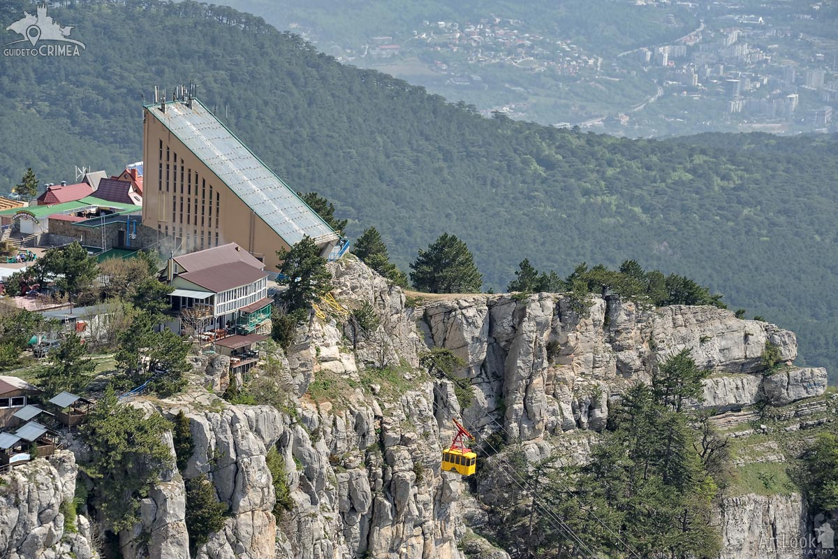
Large yellow cable car cabin moving down from a station at the top of Ai-Petri (St. Peter) Mountain. Buildings at the edge of Yalta city are visible don’t the mountain (1200 meters above sea level) in the background of the picture.
Photo #038 taken on May 04, 2017
| Album | Ai-Petri Mountain |
| Category | Landscapes |
| Taken | May 4, 2017 |
| Uploaded | November 7, 2019 |
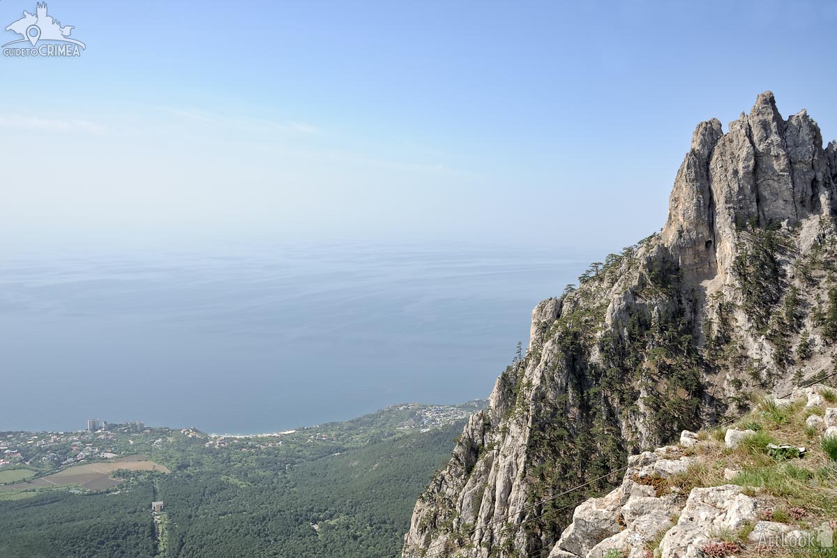
Beautiful landscape at the peak of Mount Ai-Petri (St. Peter) with the view of the Figured Teeth, the 60-80 m high ridges formed during the weathering of heterogeneous reef limestones, and the coast of Black sea where located resort settlements Koreiz (down at the left) and Alupka (down at the right).
Vorontsov Palace and Park, one of the oldest and largest palaces in Crimea, situated in Alupka, at the foot of Ai-Petri Mountain.
Photo #070 taken on May 04, 2017
| Album | Ai-Petri Mountain |
| Category | Landscapes |
| Taken | May 4, 2017 |
| Uploaded | November 7, 2019 |
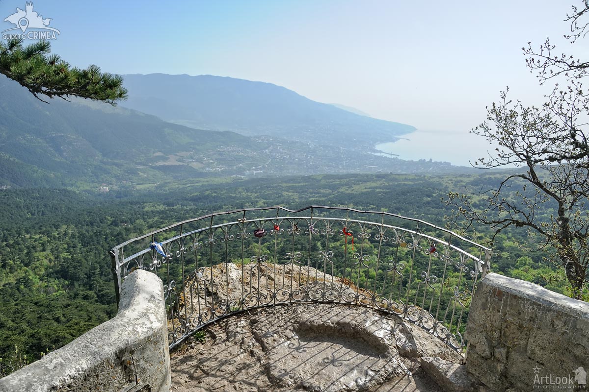
Overview Yalta Bay, Yalta city and its surroundings on the shore of Black Sea from Silver Arbor, the amazing observation spot located on the way to the peak of Mount Ai-Petri. Below the arbor is a waterfall Uchan-Su and magnificent centuries-old pine forest at the foot of the hill Pendikyul. The locks of love left by just married couples on the small fence protecting this observation deck. The Silver Arbor is an ecological and educational object located the Pendikul mountain at the height of 848 meters above sea level. The arbor was established in 1894 in honor of builders of the road Yalta – Ai-Petri – Bakhchisarai.
Photo #035 taken on May 04, 2017
| Album | Ai-Petri Mountain |
| Category | Landscapes |
| Taken | May 4, 2017 |
| Uploaded | November 5, 2019 |
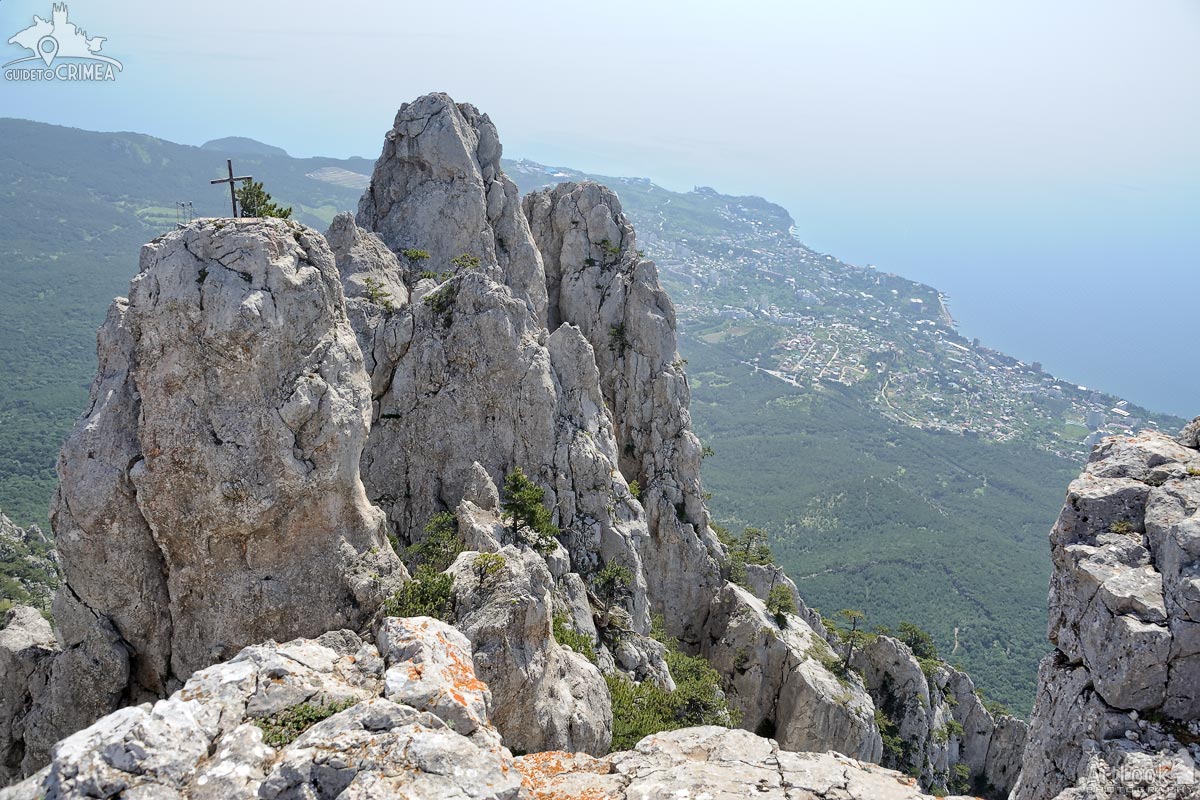
View from the observation area at the peak of Mount Ai-Petri on the Figured Teeth, the 60-80 m high ridges formed during the weathering of heterogeneous reef limestones, in the background of resort settlements Koreiz and Gaspra (far away) at 1200 meters above sea level. In a summer season, a rickety suspension bridge is set to the rock with a cross with the sign “Bless and Save”.
Photo #148 taken on May 04, 2017
| Album | Ai-Petri Mountain |
| Category | Landscapes |
| Taken | May 4, 2017 |
| Uploaded | November 4, 2019 |
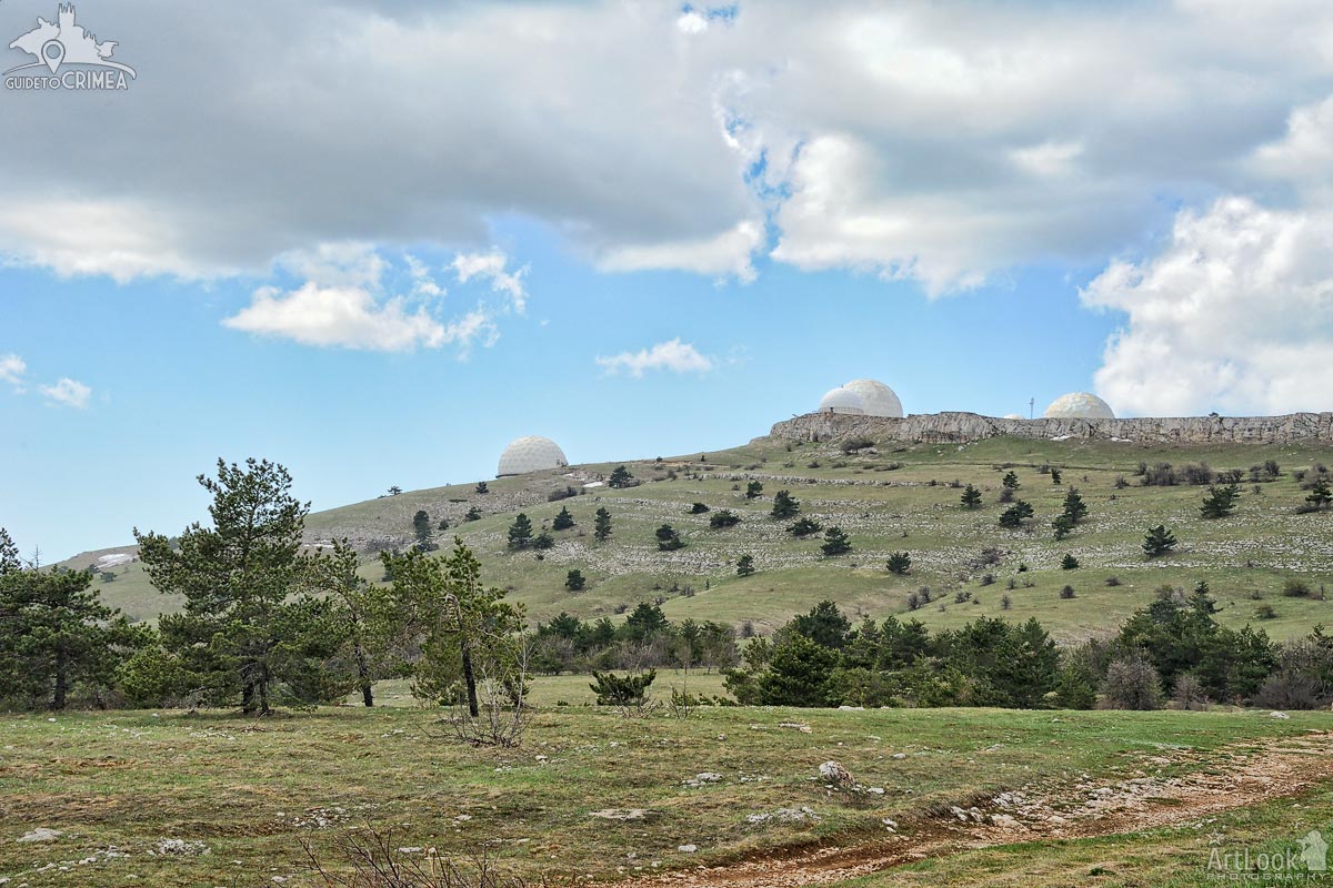
The spring landscape of the upper plateau of Mount Ai-Petri overlooking the huge white balls of the radar complex on the top of the Bedene-Kır mountain. Bedene-Cyr in Turkic means Quail Mountain.
White patches of unmelted snow on the plateau at a height about 1,2 km above sea level are still visible on the plateau surface. The complex of radar stations (RLS) is located on the top of Bedene-Cyr (Quail ) Mountain and is classified as “secret”. It is the highest plateau’s peak of 1334 meters above sea level.
Photo #331 taken on May 04, 2017
| Album | Ai-Petri Mountain |
| Category | Landscapes |
| Taken | May 4, 2017 |
| Uploaded | November 4, 2019 |
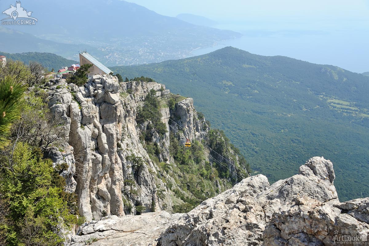
View from the highest point of Ai-Petri mountain, the peak in the Crimean Mountains with the famous figured teeth, on the aerial cableway with a cute yellow car on the way down from the plateau (height about 1200 meters). The bay of Yalta city located on the site of an ancient Greek colony is in the background of the picture.
Photo #209 taken on May 04, 2017
| Album | Ai-Petri Mountain |
| Category | Landscapes |
| Taken | May 4, 2017 |
| Uploaded | November 4, 2019 |
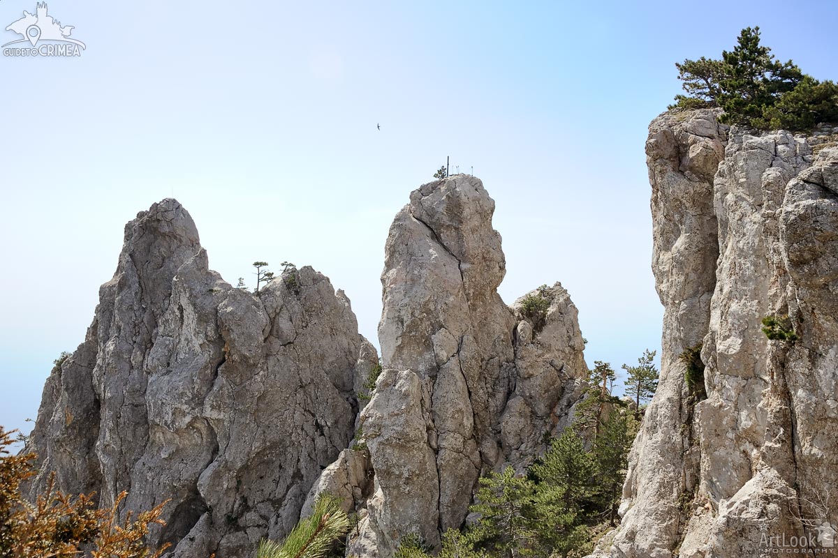
View of a bird flying over the famous figured teeth at the peak the highest point of Ai-Petri mountain, the peak in the Crimean Mountains. The teeth of Ai-Petri consist of four large (60-80 m high) and a number of small ridges on the crest formed during the weathering of heterogeneous reef limestones at 1200 meters above sea level. Beautiful relict pine trees can be seen on the top and between the ridges that growing all around in the Crimean mountains.
Photo #193 taken on May 04, 2017
| Album | Ai-Petri Mountain |
| Category | Landscapes |
| Taken | May 4, 2017 |
| Uploaded | November 4, 2019 |
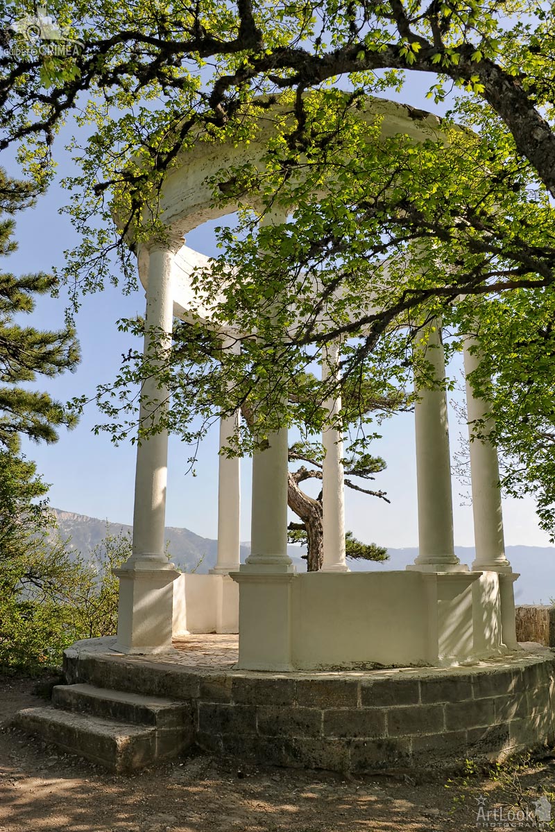
The Silver Arbor framed by trees on the way from Yalta to the top of Ai-Petri mountain by car. It is an ecological and educational object located the Pendikul mountain at the height of 848 meters above sea level. The arbor was established in 1894 in honor of builders of the road Yalta – Ai-Petri – Bakhchisarai.
In the winter the arbor becomes covered with light hoarfrost, creating an illusion of transfusion in the sunshine a thin layer of silver. From this, the name “Silver Arbor” appeared. From a rotunda of the arbor opens the scenic views on the Yalta amphitheater, Nikitskaya Yayla, Mount Au-Dag, the oak and juniper woods of the cape Martyan and the amazing coast of the Black Sea.
Photo #032 taken on May 04, 2017
| Album | Ai-Petri Mountain |
| Category | Architectural |
| Taken | May 4, 2017 |
| Uploaded | November 4, 2019 |
Crimean landscape with the view of a waving road in the South-West of the plateau leading to the highest point of Ai-Petri, the peak in the Crimean Mountains with the famous figured teeth. The teeth of Ai-Petri consist of four large (60-80 m high) and a number of small ridges on the crest formed during the weathering of heterogeneous reef limestones at 1200 meters above sea level. Ai-Petri is one of the windiest places in Crimea. The wind blows for 125 days a year, reaching a speed of 50 m/s (110 mph).
Photo #061 taken on May 04, 2017
| Album | Ai-Petri Mountain |
| Category | Landscapes |
| Taken | May 4, 2017 |
| Uploaded | November 4, 2019 |

Beautiful view at the beginning of hiking tour to the peak of Sokol mount on the Green Bay, Koba-Kaya Mountain (Mount Orel, Eagle), and resort settlement Novy Svet (New World).
Photo #083 taken on August 31, 2015
| Album | Mount Falcon (Kush-Kaya) in Novy Svet |
| Category | Landscapes |
| Taken | August 31, 2015 |
| Uploaded | October 23, 2019 |
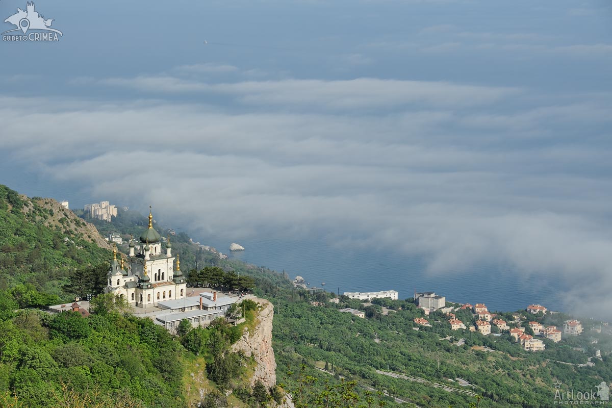
View from Baidarsky Pass on the Church of Christ’s Resurrection raising on the Red Cliff (Krasnaya Skala) over the low clouds at Foros settlement on the Black Sea in a spring season. The magnificent church, that combines Rastrelliesque Baroque, Russian Revival, and Byzantine Revival styles, was built in 1892 by the project of Russian architect Nikolai Chagin on the abrupt 400-meter (1312 ft) cliff. Alexander Kuznetsov, the Moscow merchant and the Russian “tea king” who had his palace built on the seashore, commissioned Nikolai Chagin, the celebrated architect from Wilno, to built the church of Christ’s Resurrection in memory of the miraculous rescue of Emperor Alexander III and his family in 1888 train crash in the Borki, on the way to St. Petersburg. The temple is notable for its luxurious exterior and picturesque interior.
Founded and named by medieval Greek merchants, Foros settlement was rediscovered in the late 19th century by Alexander Kuznetsov. It is located at the most Southern coast of Crimean Peninsula, in the middle between Yalta and Sevastopol.
Photo #593 taken on May 05, 2017
| Album | Foros Church of the Resurrection of Christ |
| Category | Architectural |
| Taken | May 5, 2017 |
| Uploaded | October 20, 2019 |
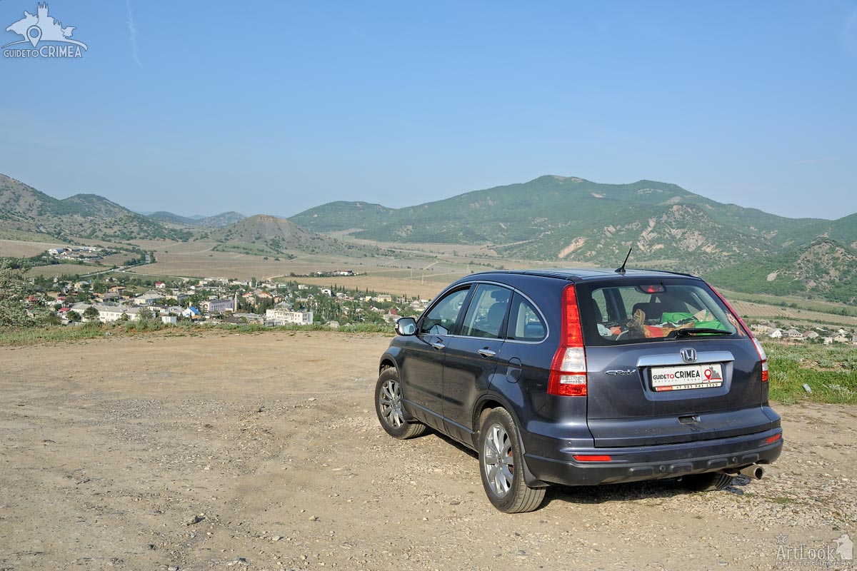
My car Honda CR-V in the background of the village of Vesyoloye (Eng translation: Cheerful, Fun) located in the valley of the Kutlak River on the southeastern slope of the Main Ridge of the Crimean Mountains. A quick stop at an observation platform overlooking landscapes in 10 kilometers East from Sudak, even closer to the village of Novy Svet (New World).
Photo #425 taken on May 06, 2017
| Album | Portfolio |
| Category | Landscapes |
| Taken | May 6, 2017 |
| Uploaded | October 19, 2019 |
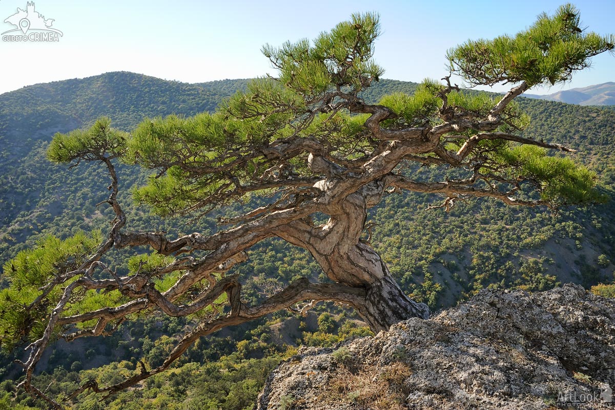
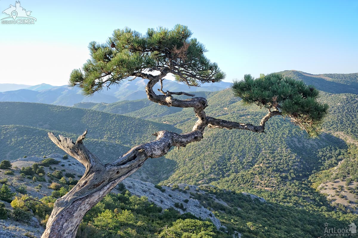
This exceptional Stankevich pine grows on a steep slope, almost at the peak (about 410 metres above sea level) of Sokol (Falcon) mountain in Novy Svet (New World). Such pine trees are very rare in nature, but they are endemic to the Sudak district on the southern coast of the Crimea peninsula. First described by the Russian botanist V.N. Stankevich, the pines were named by the academic V. N. Sukachev in 1906 in his honor. They are also known as “Sudak Pines”- after the region in which they are found. The pine tree in this photograph is about 200 years old.
Photo #222 taken on August 31, 2015
| Album | Mount Falcon (Kush-Kaya) in Novy Svet |
| Category | Landscapes |
| Taken | August 31, 2015 |
| Uploaded | October 10, 2019 |
View at the peak of Sokol (Falcon) Mountain, 474 meters above the level of Black Sea, peaceful “Zelenaya Buhta” (Green Bay) and the settlement of Novy Svet (New World), down the mountain at sunset.
Photo #254 taken on August 31, 2015
| Album | Mount Falcon (Kush-Kaya) in Novy Svet |
| Category | Landscapes |
| Taken | August 31, 2015 |
| Uploaded | October 10, 2019 |
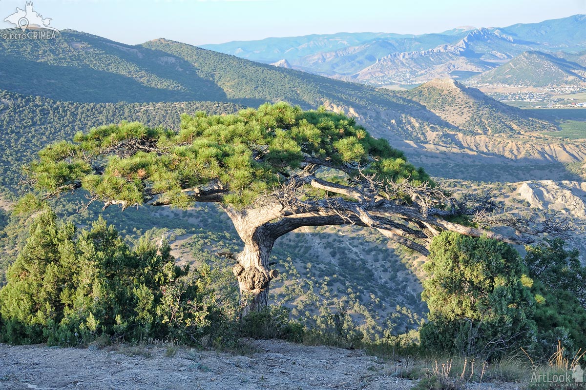
Beautiful Crimean landscape with the exceptional Stankevich pine growing on a slope of Sokol (Falcon) Mountain in Novy Svet (New World) in the background of the mountain range.
Such pine trees are very rare in nature, but they are endemic to the Sudak district on the southern coast of the Crimea peninsula. First described by the Russian botanist V.N. Stankevich, the pines were named in his honor by the academic V. N. Sukachev in 1906. They are also known as “Sudak Pines”- after the region in which the trees were found.
Photo #348 taken on August 31, 2015
| Album | Mount Falcon (Kush-Kaya) in Novy Svet |
| Category | Landscapes |
| Taken | August 31, 2015 |
| Uploaded | October 10, 2019 |
The big Sudak pine on the slope of Sokol Mountain (Falcon Mountain) in Novy Svet in the background of the mountain range in Sudak district. The tree is used by people who climb on the mount as an object of wishes and offerings. This type of trees in Sudak was called Stankevich pine by the name of famous Russian botanist who found and described it in 1906.
Photo #384 taken on August 31, 2015
| Album | Mount Falcon (Kush-Kaya) in Novy Svet |
| Category | Landscapes |
| Taken | August 31, 2015 |
| Uploaded | October 10, 2019 |
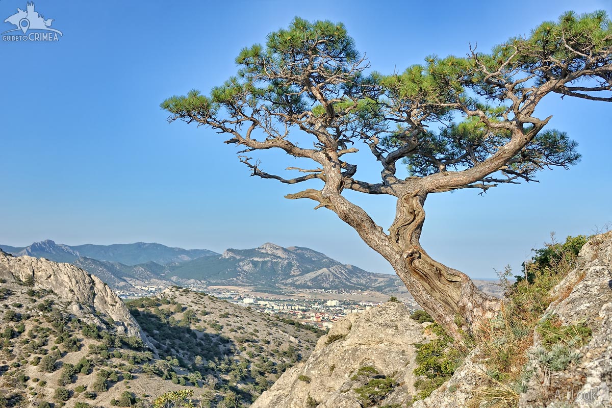
Beautiful Stankevich pine tree growing on a steep slope of Sokol (Falcon) mountain in background of a valley where located Sudak city. Such pine trees are very rare in nature, but they are endemic to the Sudak district on the southern coast of the Crimea peninsula. First described by the Russian botanist V.N. Stankevich, the pines were named by the academic V. N. Sukachev in 1906 in his honor. They are also known as “Sudak Pines”- after the region in which they are found.
Photo #149 taken on August 11, 2019 during hiking tour on the peak of Sokol mountain with my dear clients from Hong Kong, Esther and Ricky (1st day of the adventure trip “Discovering Crimea within 6 Days”)
| Album | Mount Falcon (Kush-Kaya) in Novy Svet |
| Category | Landscapes |
| Taken | August 11, 2019 |
| Uploaded | October 10, 2019 |
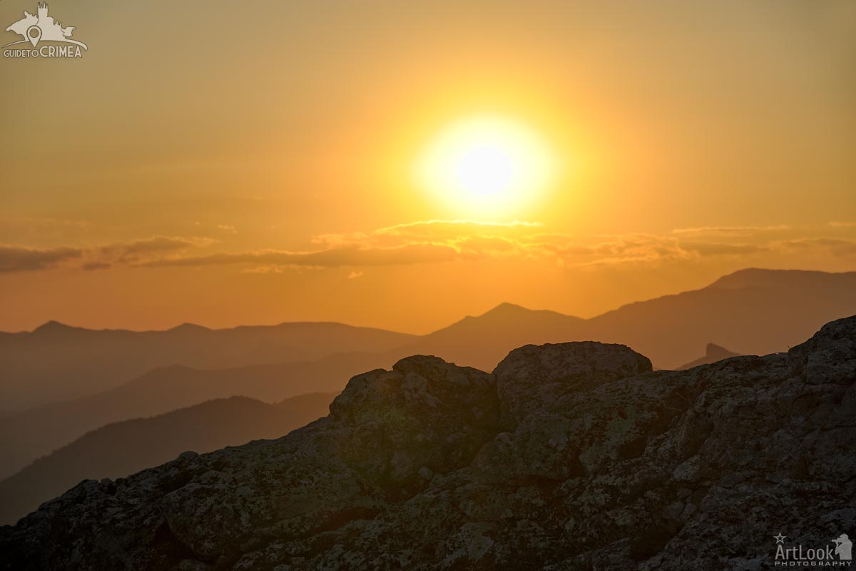
Overview beautiful sunset over Crimean Mountains from the peak of Sokol (Falcon) mountain (about 470 meters from a sea level) at Novy Svet, few kilometers from Sudak, the Sothern shore of Crimean Peninsula.
Photo #208 taken on August 11, 2019 during hiking tour on the peak of Sokol mountain with my dear clients from Hong Kong, Esther and Ricky (1st day of the adventure trip “Discovering Crimea within 6 Days”)
| Album | Mount Falcon (Kush-Kaya) in Novy Svet |
| Category | Landscapes |
| Taken | August 11, 2019 |
| Uploaded | October 10, 2019 |
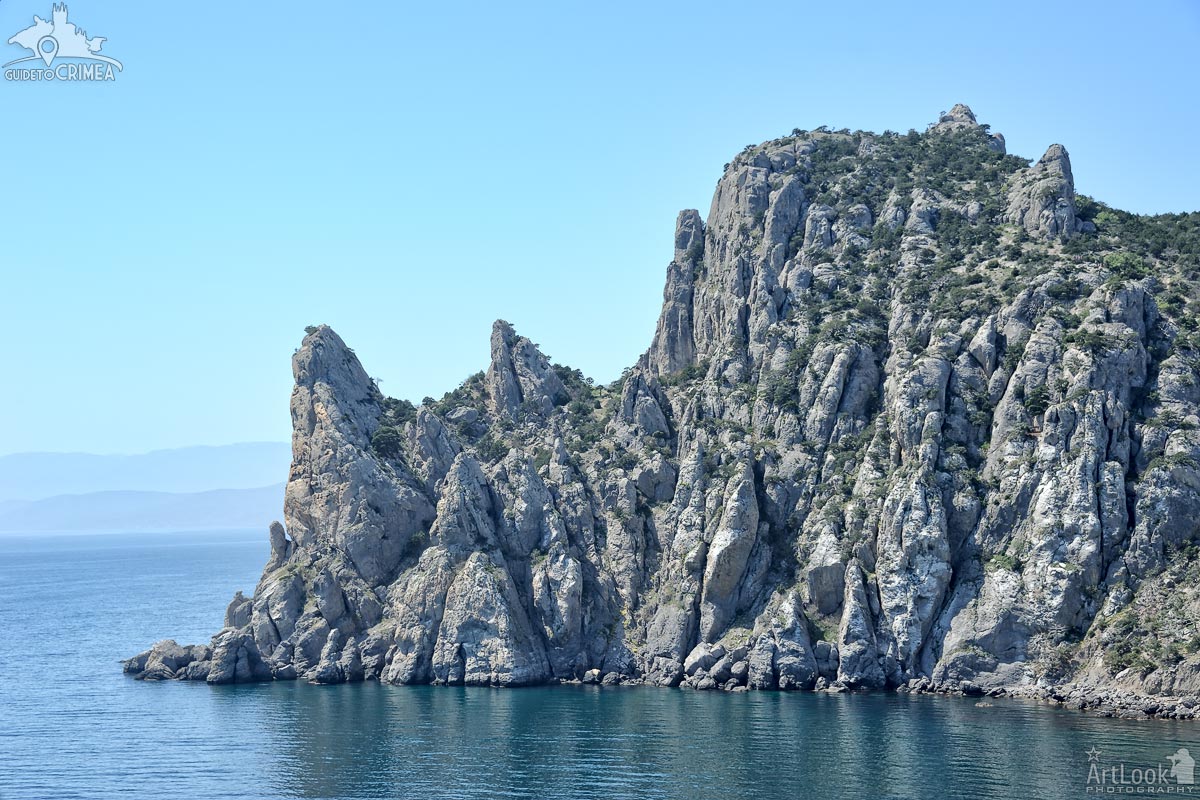
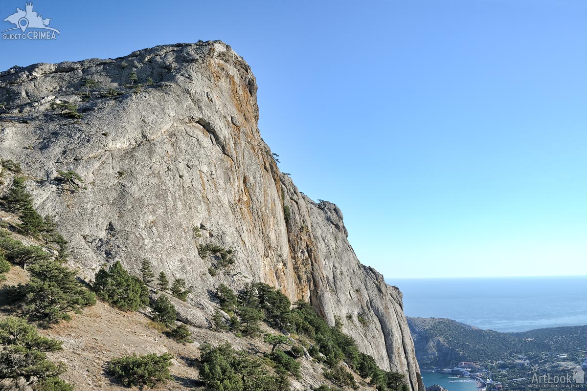
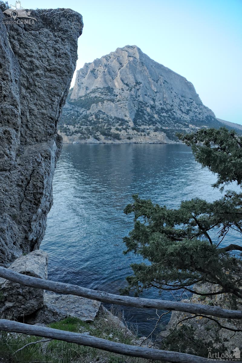
The view on the edge of the ancient coral reef of the Jurassic period, the mount Karaul-Oba (Tatar: Qaravul Oba, Russian: Karaulnaya), from Cape Kapchik, located a few kilometers westwards from Novy Svet (New World) settlement, on the tourist path of Golitsyn. The Karaul-Oba massif with its mystic rocky ledges is the state complex natural monument. Almost from the very sea, sharp teeth of the cliffs are jutting out, that is a distinctive feature of the mountain. ‘Karaul-Oba’ means ‘Watch Mountain’ or ‘Guard Peak’ in Crimean Tatar. It is reckoned among many unique natural wonders of Sudak’s surroundings.
Photo #079 taken on May 01, 2017
| Album | Golitsyn Trail in Novy Svet |
| Category | Landscapes |
| Taken | May 1, 2017 |
| Uploaded | October 7, 2019 |
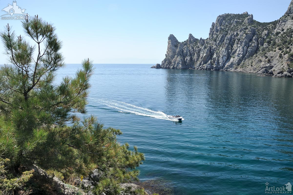
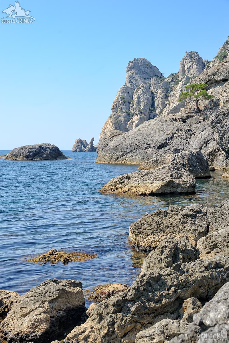
View of a boat with tourists entering the Blue Bay (Golubaya Buhta) in Novy Svet (New World), where located the famous Tsar beach in Suzdak district in Crimea. The sharp teeth of the cliffs of the mount Karaul-Oba (Tatar: Qaravul Oba, Russian: Karaulnaya) are in the background of the picture. This ancient 341-meter-high coral reef of the Jurassic period (341 m.) has rather a complicated specific structure: plateau-like area with rock walls, crevices, ridges, stone labyrinths are replaced by deep long saddles. The rocky ledges of Karaul-Oba massif is a State complex natural monument and reckoned among many unique natural wonders of Sudak’s surroundings.
Photo #095 taken on May 01, 2017
| Album | Golitsyn Trail in Novy Svet |
| Category | Landscapes |
| Taken | May 1, 2017 |
| Uploaded | October 7, 2019 |
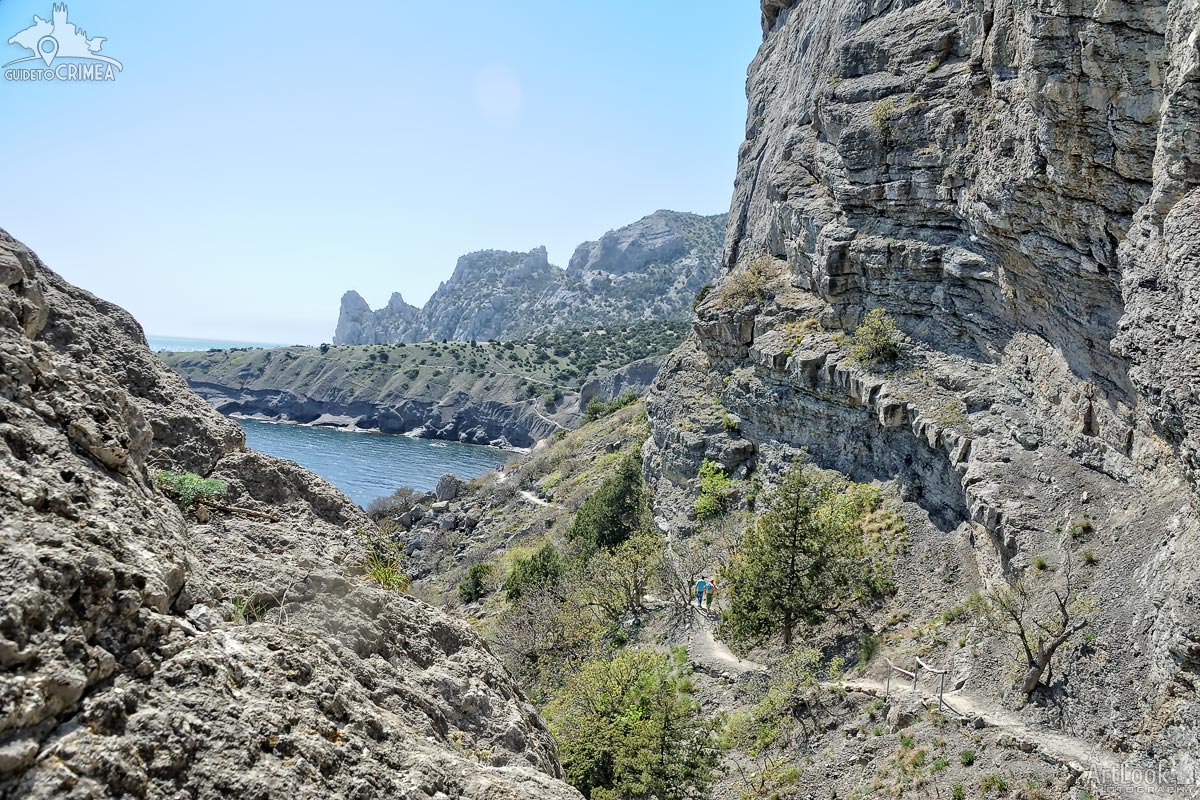
Walking between rocks along the famous trail Golitsyn to the cape Kapchik and the mount Karaul-Oba (Karaulnaya), the ancient 341-meter-high coral reef of the Jurassic period., located near Novy Svet (New World) settlement.
Novy Svet (New World) settlement is the well-known resort in Sudak district, the South-eastern part of the Crimean Peninsula, Black Sea, Russian Federation, that boasts its beautiful landscapes, mountains, beaches and factory of sparkling vines established by Prince Lev Golitsyn in 1878.
Photo #160 taken on May 01, 2017
| Album | Golitsyn Trail in Novy Svet |
| Category | Landscapes |
| Taken | May 1, 2017 |
| Uploaded | October 7, 2019 |
View from a tourist path of Golitsyn on the Sokol (Falcon) Mountain framed by a pine tree and a rock at the bottom of Oryol (Eagle) Mountain at Novy Svet (New World) settlement after sunset, before it was get dark. The popular village-resort is located on the coast of the Zelenaya Buhta (Green Bay) between these mountains.
Photo #388 taken on April 30, 2017
| Album | Golitsyn Trail in Novy Svet |
| Category | Landscapes |
| Taken | April 30, 2017 |
| Uploaded | October 7, 2019 |
Golubaya Buhta (Blue Bay) is a captivating area of the Crimean coastline of Novy Svet (New World). On the steep slope of this rocky yet beautiful coastline grows a rare and solitary Stankevich pine tree that is endemic to Sudak (the south Crimean coast).
Also located in Golubaya Buhta (Blue Bay) is the famous Tsraskiy Plyazh (The Tsar’s Beach), so named because this was where Nicholas II enjoyed to swim during his visit to Novy Svet in 1912.
Photo #086 taken on September 02, 2015
| Album | Golitsyn Trail in Novy Svet |
| Category | Landscapes |
| Taken | September 2, 2015 |
| Uploaded | October 7, 2019 |
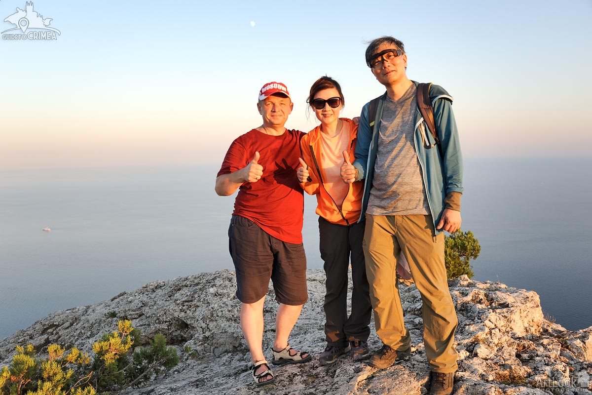
Memory photo of me, Arthur Lookyanov, and my clients and friends from Hong Kong, Esther and Ricky, standing on the peak of Sokol (Falcon) Mountain in Novy Svet (New World). The picture was taken on my camera by our local guide in Sudak after 2,5 hours climbing on the mount.
Photo #202 taken on August 11, 2019 during a hiking tour in Novy Svet on the 1st day of the adventure trip “Discovering Crimea in 6 Days”.
Mount Sokol: Climb to the Top of the Highest Coral Reef in Europe

A legend says that in the old days, when people had not yet lived in Crimea, two birds fought over the sea – an eagle and a falcon. The falcon was younger, the eagle was stronger, and it is not known who would have won if the sea had not been angry. It was it […]
